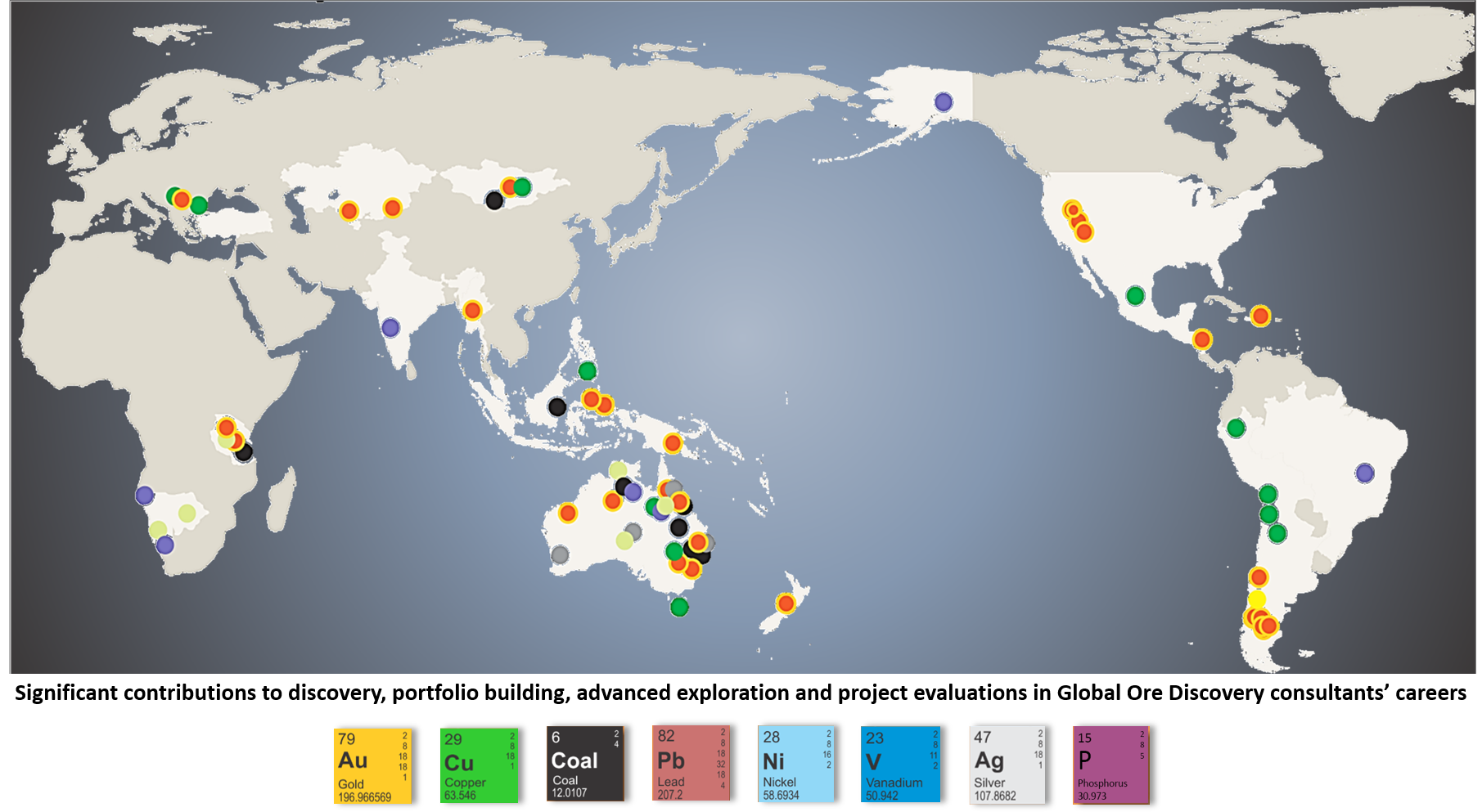

Connecting geoscience and corporate strategy with a focus on success for our clients
- Industry leading integrated geoscience services for minerals exploration focused on discovery
- International consulting experience in a wide range of commodities and deposit styles, from greenfields exploration to mine development
- Globally integrated IT systems designed, built and operated to capture, secure and distribute data to maximise its value
- Corporate secretary and administration services, including building integrated accounting and budget management systems
- Tailored marketing materials integrated with corporate marketing strategy to deliver clear, concise message to investors
- Extensive resource industry network to connect clients with project joint venture and acquisition opportunities
Global Ore’s management team and specialist geoscientists provide a full range of professional geoscience and corporate services to help you realise a project’s full potential.
- Research, develop and apply new exploration concepts to terrain-scale analysis
- Acquire, collate, process and interpret large terrain-scale datasets and build unique GIS-based targeting frameworks
- Interpret tectonic and magmatic controls on mineralisation
- Identify and prioritise prospective mineral systems, recommend acquisitions and secure free-ground
- Provide managers extensive detailed exploration budgeting support including items, people time, contractor costs, expenditure timeline and expected program outcomes
- Collaborate with exploration teams to determine and arrange technical details including field sample collection protocols and laboratory analysis methods
- QAQC process and control sample selection
- Geophysical survey acquisition specification and data processing
- Remote sensing and alteration/spectral data collection, processing and mineralisation vector analysis
- Collaborate with project managers to monitor exploration results, supervise real-time priority changes and maintain cost control
- Integrate validated exploration program results with previous GIS datasets and maintain version control
- Analyse integrated datasets in 2D and 3D and rank priority targets
- Provide constant updates and recommendations on exploration progress to management, re-prioritise exploration activities and budgets based on results
- Collaborate with in-house teams to design and plan JV exploration programs
- Work alongside project managers to coordinate senior exploration staff and field teams to deliver on exploration programs
- Monitor and reconcile exploration budgets against expenditure and provide cost control solutions / recommendations to management
- Collate and organise exploration data and ensure valid information is used for JV partner reporting and public news releases
- Develop exploration models and provide integrated geological analysis to support geologists and country managers
- Prepare technical presentations and present JV exploration progress and technical updates at quarterly meetings
- Work with in-house GIS team to compile unique open file geological, geochemical, remote sensing and geophysical datasets at a prospect scale
- Process, interpret and integrate geophysics and remote sensing data to define alteration zonation, structural fabric, geochemical anomalies and geologically permissive settings to design reconnaissance scale field programs and focus field exploration teams within large scale systems
- Undertake interactive real time analysis of results with field teams to refine exploration programs while teams are in the field to maximise results from programs and improve exploration cost effectiveness
- Compile, validate, process and interpret first pass field geological and geochemical data for design of detailed follow-up field programs including geophysics programs.
- Liaise with geophysical survey providers and data processing specialists to deliver products to specification and in the required format to facilitate integrated interpretation
- Collaboratively with management and senior geologists review claims for potential relinquishment
- Work with management, geochemical database staff and geologists to define program specific sampling methodology, assay sample suite, analytical techniques and standard insertion rates to deliver high quality exploration results that are reportable by a CP/ QP
- Build project specific technical interpretations for use in business development materials
- Advise on QAQC (quality assurance and quality control) protocols and laboratory methods specific to individual projects, mineralisation-style and exploration programs.
- Design, budget and maintain a geochemical and geological relational database specific to field and QAQC requirements
- Train field and geologists in data capture, validation despatch and data distribution protocols
- Deliver timely QAQC reports on an ‘as-received’ batch basis to CP/QP, JV partners and project geologists, highlighting any potential issues with assay results and/or laboratory performance.
- Ensure databases are compliant with international standards for public news releases and resource estimation reporting:
– Sample information received from field teams to laboratory assay results
– Validated data for immediate use in interpretation and program planning - Provide recommendations on re-analysis protocols so samples or batches that fail QAQC initially may later be validly included by CP / QP in news releases and public reports.
- Schedule and maintain a Cloud-based data backup system and conduct database integrity checks.
- Assess requirements and identify cost-effective sensors or satellites for image acquisition
- Plan and “task” new satellite data acquisition and/or identify cloud-free imagery stored in online databases and convert to a format that can be processed using proprietary Global Ore algorithms
- Perform specialised spectral data processing to produce alteration mineral occurrence and abundance maps and/or digital elevation models and/or false colour imagery and/or base imagery over exploration targets and supply to Global Ore’s targeting team and field geologists
- Integrate alteration mineral mapping products with geology, geophysics, field data and structural interpretations as part of integrated targeting
- Collaborate with field teams to ground-truth anomalies associated with mineralisation indicators